Friday, August 17, 2012

Travelers in New York


Our travels have brought us to Saratoga Springs, New York, where we are spending several days visiting Lee's mother. Betty is not part of the digital world and has not been able to follow our adventures through the blog. Over the months, Lee was faithful to keep in touch with phone calls and frequent packages containing photos and travel descriptions. It is a treat now for both of them that they can share in person, as they are doing in this photo with the atlas between them.

To get to Saratoga Springs from Michigan we drove on Sunday across the St. Clair River from Port Huron, Michigan, to Sarnia, Ontario. This was my first visit to Canada, although Lee has traveled there a number of times. Once across the bridge (not a speedy process) we stopped at the Visitor Information for maps and brochures. By this time it was mid-afternoon and we hoped to find a campground before dark. All of the provincial parks in this part of Ontario are on Lake Ontario and would have been somewhat out of the way. But we discovered that there were many private campgrounds along our route.

About 10 miles east of London, Ontario, we stopped for the night at a quiet, very clean place called Casey's Campground. It was a first for me to camp in Canada. And there was another first for both of us the next morning shortly after breakfast when the electricity went out. As tent campers we don't require an electric hookup but it did mean no water, restrooms or showers until power was restored. The campground owner assured us that he was doing his best to monitor the situation. And it wasn't too long before the power came back on and we were able to finish getting ready for our day.

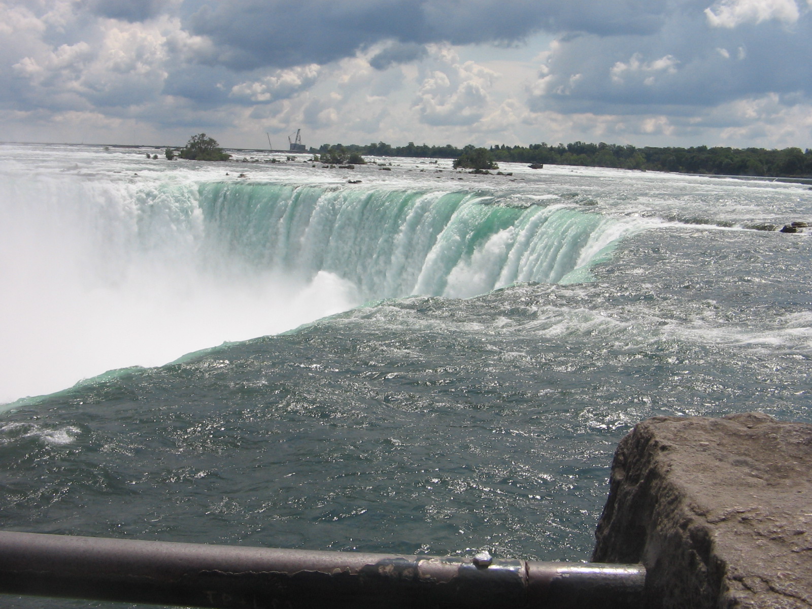
This was the day that we made our visit to Niagara Falls. Now I have another breathtaking wonder of nature that I can add to the list of sights seen on our travels.

Horseshoe Falls

A surprisingly drastic drop-off where the Niagara River tumbles over Horseshoe Falls.

Maid of the Mist boat in the background takes passengers to the base of Horseshoe Falls.


American Falls


After filling up on the awesome beauty of Niagara we drove the length of the 30-mile Niagara Parkway that follows the Niagara River from the falls down to the bridge crossing at Fort Erie. We enjoyed the drive with views of the river on one side and beautiful estates and mansions on the other side. At Fort Erie we crossed the Peace Bridge, coming back into the US at Buffalo, New York.

Our stop for the night Monday was a motel in Canandaigua, a small town on the northern end of the lake with the same name (a name that I had a very hard time pronouncing)! This lake is, practically speaking, the westernmost of the series of lakes in New York called the Finger Lakes. A look at a map of New York state shows why this is a fitting name.

Tuesday before leaving Canandaigua we rode our bikes partway around the lake on a road along the western side of the lake.  The Finger Lakes are in a part of the state that is quite hilly and we did get to stretch our leg muscles on several good-sized hills.

Bike ride on road along Canandaigua Lake

View of Canandaigua Lake

Tuesday night was another camping opportunity, this time at a New York state park next to Caroga Lake at the southern edge of Adirondack Park.  Our tent kept us warm and dry during the night as some heavy rainstorms moved through the area.

We are adjusting now to the northeast, which has not suffered from the heat and drought we experienced for months on our travels in the west and midwest.  It is nice to see green again and flowers gardens that have not wilted or dried up.  We look forward to this weekend where we will be visiting the Regans again, this time at the cottage they have rented on Sacandaga Lake.


Sunday, August 12, 2012

Are We In Hawaii?


Wow, did we finally find a place where the weather is perfect and the sparkling, sandy beaches await our eternal relaxation? Unfortunately, even if such a place exists, it is not where we were yesterday when this picture was taken.

Friday we left Bowling Green, Ohio, and drove north towards Standish, Michigan. After weeks of hot, dry weather throughout the Midwest the weather pattern took an extreme shift in the opposite direction. It was overcast and drizzly in Ohio and we knew that there would also be rain in Michigan. But we weren't prepared for the amount of rain and for the drop in temperatures.

Our destination was Saginaw Bay Resort where a family reunion was planned for Saturday. We were going to camp there Friday night. But as the rain increased and the temperatures decreased we realized that we would have to change plans. Cousin Terri has a summer home on the bay less than 2 miles from the resort and when she offered us accommodations there for the night we were more than happy to accept.

After a restful, dry sleep at Terri's house we awakened to another chilly, gray day. But at least the heavy rains had given way to only scattered showers. Terri and other family members who planned the reunion did a marvelous job of working around the uncooperative weather to find a place to set up the noon meal where the family would gather. Tables were set up in one end of the resort's pavilion and there was plenty of space for our group to grill and enjoy the dishes everyone had brought. The theme of the week at the resort was Hawaiian and the pavilion was set up for a special dinner later that afternoon for all the resort guests. That explains why we found the photo op in the pavilion of 2 happy Hawaiian travelers.

It wasn't Hawaiian weather by any means, but it isn't the weather that counts when a family comes together. What counts is that you are with people that you care about and who care about you. It was wonderful to see everyone and spend the afternoon catching up with each other. This side of the family doesn't gather together as often as we should. Special thanks to Terri and Kathy and their families for providing the time and place and doing all the hard work to bring this together.

Lee and I are now setting out to cross over into Ontario from Port Huron, Michigan. We will spend a couple of days camping in Ontario, making our way to Niagara Falls, a place that I have not yet seen, but am sure will be beautiful. From there, our destination will be upstate New York where we will visit Lee's mother and reconnect again with Lee's brother and sister-in-law at their annual stay at Sacandaga Lake in the Adirondacks. Let's hope the weather warms back up and that summer isn't over yet.

Monday, August 6, 2012

Greetings from Ohio

Our year of travel and being "homeless" has been a great adventure, but it has also been a wonderful opportunity to stop at various locations in the country and spend time with family and friends we wouldn't otherwise see because they don't live nearby.  The plaque above in the guest bedroom here at the Regan's house in Bowling Green, Ohio, is a reminder that home is much more than a street address where we receive our mail and place our belongings.

Before we arrived in Bowling Green we spent a couple of days in rural western Ohio visiting our friend, Jerry, at his home in Maria Stein.  When we met Jerry last winter in Florida he told us about Maria Stein but neither of us had heard of it before and were not familiar with that part of Ohio.  Jerry has lived there all of his life.  His knowledge of the area and its people and his eagerness to share that knowledge with us was a delightful learning experience.

Mercer County, where Maria Stein is located, has a nickname "Land of the Cross-Tipped Churches."  It's an appropriate name as you look around from nearly any location in the area and see one or more of the church steeples in the surrounding communities.  The area was settled in the early 19th century by German immigrants who were almost all devout Catholics.  Under the leadership of the missionary priest, Francis de Sales Brunner, the Society of the Most Precious Blood founded many churches and schools in the region, as well as several seminaries.   The name Maria Stein, in German means "Mary of the Rock".  Besides St. John's Church, one of the "cross-tipped" churches that is here, Maria Stein is also home to the Shrine of the Holy Relics, which has beautiful park-like grounds where Jerry gave us a walking and biking tour.

St. Sebastian Church in the community of St. Sebastian, about 5 miles from Maria Stein.


Taking a rest stop in front of St. Sebastian Church.


Jerry also led us on a bike ride to nearby Grand Lake St. Mary's.  This lake is Ohio's largest inland lake and has the distinction of being the largest hand dug lake in the world.  When it was completed in 1845 it was the largest man made lake in the world, but since the advent of power equipment to accomplish such tasks there are obviously now man made lakes larger than this one.  Looking at the size of this lake (13,500 acres) it was hard to imagine that it was all dug by hand--one sign said it took about 1,700 laborers working for 8 years at a rate of 30 cents a day (and a jigger of whiskey for malaria prevention) to accomplish the task.
View across Grand Lake St. Mary's from southwestern end.

After an enjoyable visit in Maria Stein, we made the relatively short drive further north and east in Ohio and arrived in Bowling Green, Ohio, in time to spend our birthdays with Lee's brother and sister-in-law.  After a much-needed rainstorm Saturday evening and Sunday morning, we are enjoying pleasantly cool temperatures and will be doing some bike riding on roads and trails around Bowling Green.

The 2 birthday kids.  Lee is holding one of his gifts, which is a snapshot of him and his brother at a much younger age.


Wednesday, August 1, 2012

Goodbye to Iowa

We've spent over 6 fun-filled weeks in Iowa, but all good things must come to an end.  Today it was time to get back on the road and continue our travels.

Our departure point for leaving Iowa was a bridge crossing of the Mississippi River from Muscatine, Iowa, into Illinois.  Just after crossing the river we took a short sightseeing detour upriver to investigate the US Army Corps of Engineers Lock and Dam No. 16.


There we learned some of the history of the Upper Mississippi River Nine-Foot Channel Navigation Project.  In order to spur commerce on the Mississippi River in 1930, Congress passed the Rivers and Harbors Act that included the 9-foot channel project.  The Upper Mississippi River channel is often too shallow for a barge or boat.  The type of barge used here needs a minimum of 9 feet of water.  To achieve a 9-foot channel the Corps of Engineers built a series of 29 locks and dams on the stretch of river from St. Paul, MN, to the Southern Tip of Illinois at Cairo.  The dams form pools that make the river navigable in the shallow areas.  The locks are passageways through the dam allowing the boats to travel from one pool to the next.

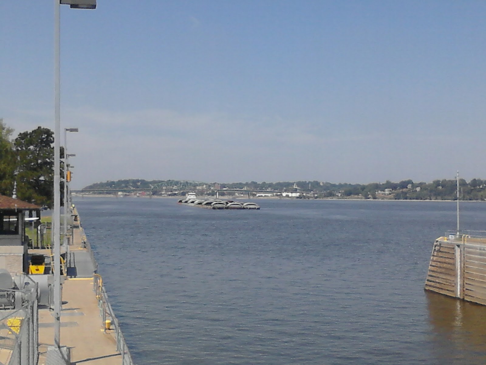
Here across from Muscatine, Iowa, we were at lock 16 of the 29.  Looking downriver from the viewing platform we were able to see firsthand how the lock works as a large 15 barge tow was making its way towards the lock.

15 barge tow approaches the lock.

Tow entering the lock


Tow doesn't all fit into the lock


If we would have stayed to watch the whole process we would have been there over an hour.  A 15 barge tow is too long to fit into the lock.  When a tow of 15 barges locks through, it is required to separate and make two lockages.  The first 9 barges are locked through, pulled out and tied off to the guide wall.  Then the second half of the tow can be locked through.

And just another set of facts and figures that we learned:  If all the material (in this case, it was coal) that is being transported on a 15 barge tow were carried by train or truck it would take 240 rail cars or 1050 semi trailers to transport that much coal.  So I guess it's worth a bit of time and patience to work these barges downriver through the dams and locks.

After leaving our history lesson on the Mississippi River the rest of the day was spent grinding out the miles on a long stretch of interstate.  We are spending the night about 50 miles west of Indianapolis, Indiana, and tomorrow will continue our drive to Ohio.

Saturday, July 28, 2012

RAGBRAI Dip Site

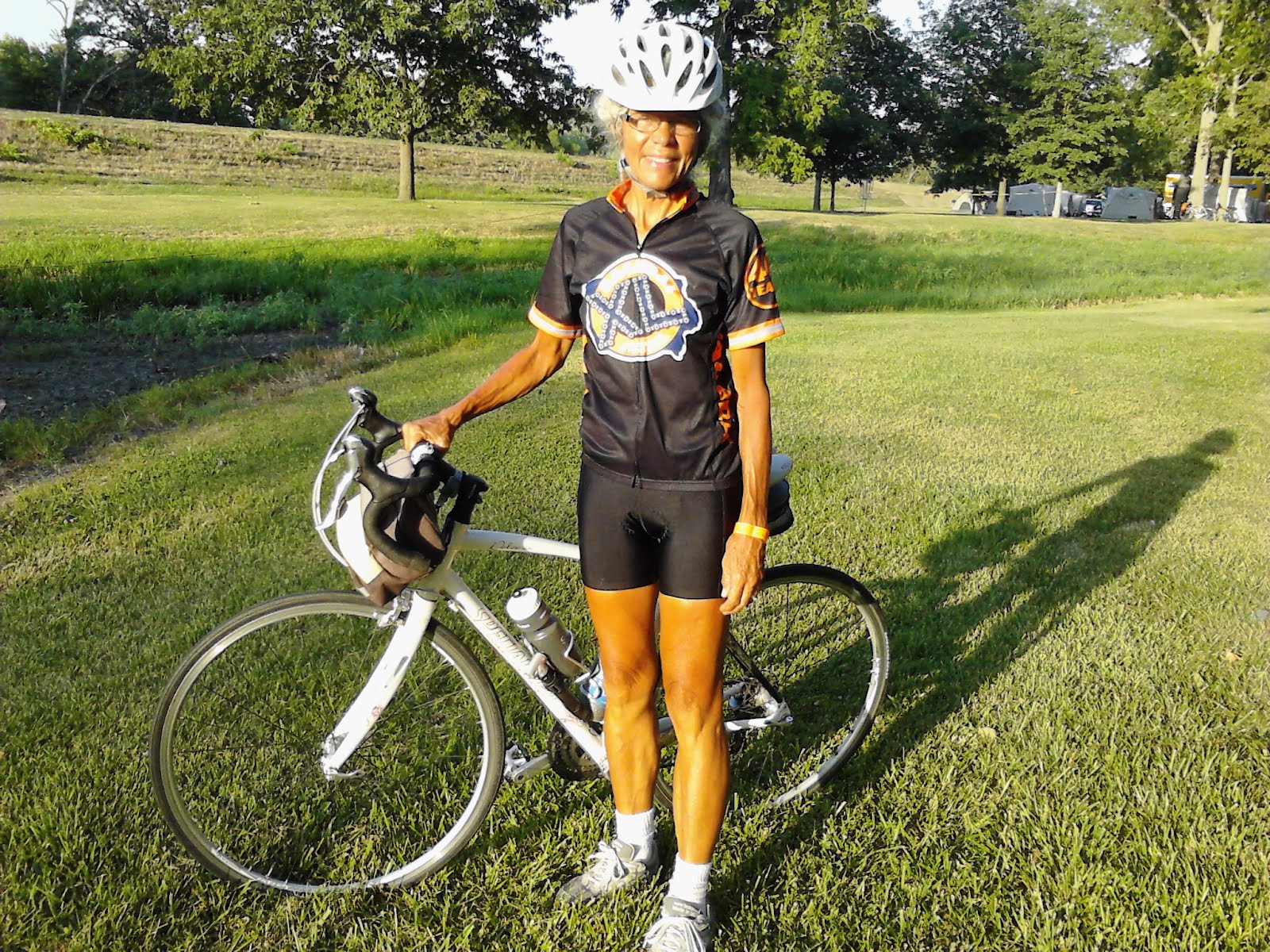
The traditional way to mark the end of the ride across Iowa is to dip your bike tire into the Mississippi River at the ending town.  Today I joined the crowd of bicyclists pushing their bikes towards the dip site in Clinton, Iowa, just so Lee could take a picture showing I was actually there.  All the hard work of the week pedaling from Sioux Center on the Missouri River to Clinton on the Mississippi River was finally done so it didn't seem that important whether I actually got the bike tire in the water or not.

As always, I had a wonderful time on the ride.  This marks the tenth year I've done RAGBRAI and I think it was the best year ever.  I may have complained about the heat and headwinds and hills but that's all part of the experience.  When you've made it to the end town you tend to forget how discouraged you felt during those long stretches of pedaling when it felt like you were never going to make it to the end of the day.

We are now back in Iowa City, staying at Mike's house for the weekend.  We have to take the car to a mechanic Monday for some minor repairs.  By Tuesday or Wednesday we plan to be on our way to Ohio to begin another round of visiting friends and family and exploring new and old places.

Thursday, July 26, 2012

Such an Easy Ride


It was such an easy ride today that I took some extra time in Vinton to try my hand at dairy production the old-fashioned way.  Sande would be proud of me.  For those of you who remember my June 8 post about the extraordinary job that my sister, Sande, does on her Wyoming ranch you would understand why I couldn't pass up this photo op.

We had lots of wind again but 90% of the time it was either a tailwind or blowing sideways.  It was so wonderful that I didn't mind the fact that there quite a few hills.  Most of the hills were the roller coaster kind that aren't that long and that are fun to descend.  Also, that kind of terrain in Iowa means the ride is scenic with views of valleys and ridges blanketed with beautiful farmland.

I didn't hear any statistics on amount of rainfall last night in Marshalltown, but it definitely wasn't enough to break the drought.  It did thunder and lightning and a severe storm warning was issued.  We were already in our tent, but talked to some riders today who said people who had gone downtown on the shuttle were told the shuttles wouldn't take them back to camp until the storm threat passed.  A group in our campground this afternoon was making repairs to their tent and drying out their clothes in the sun.  They said when the shuttle finally got them back to camp they discovered the wind had blown over their tent.

Even if the nights camping on RAGBRAI don't have storms there are other hazards to watch out for.  Have you ever experienced the frustration of leaving your car in a parking lot while you shop and then when you come out of the store you can't figure out where you left it?  That frustration can't compare to what a fellow camper experienced last night.  At 3:30 in the morning Lee heard me getting out of the tent to go to the bathroom and asked if he could walk with me since he'd forgotten his flashlight.  When we exited the tent a panic-stricken woman saw our light and told us her sad story.  She had gone to the restroom but then had gotten disoriented in the dark and couldn't find her tent.  We stumbled around with her awhile with no success and finally left her back at the restroom where she started so she could try to retrace her steps.  It's awful what an unorganized, huge jumble of tents fills a RAGBRAI campground.  When the restrooms are far away like they were last night I always dread those middle of the night restroom visits.  I could end up wandering around until daylight lost and unable to find my tent.

Here in Cedar Rapids we have a much nicer camping spot.  The restrooms are close and the skies are clear.  It should be a hazard-free night.  I'll need a good night's sleep.  Tomorrow is the day with the most hills on this year's ride.

Wednesday, July 25, 2012

Into the Wind

Yesterday's east wind that someone said would bring in rain and cooler temmperatures appeared this morning to have brought only more wind.  The wind today was from the south and, of course, a lot of the route had us heading into the south.  So once again the afternoon part of the ride really stretched the lungs and leg muscles to push against the wind and some uphills, too, that greeted us on the way into Marshalltown.  The temperatures were triple digits, as well.

But now we can rest knowing another day has been conquered.  And what is that sound as darkness falls and we are here in our tent?  Wow, it's actually raining.  And what a wonderful cool breeze the rain has brought.  The forecast is that it won't be a significant amount of rain but it will bring much cooler air for tomorrow's ride.

Before this week had started I had been dreading tomorrow's ride.  It's the longest of the week and 84.8 sounded like an awful lot of miles.  But after strengthening my leg muscles battling the winds yesterday and today I feel more than ready for the challenge.

Tuesday, July 24, 2012

An East Wind Brings Rain?

About halfway through the morning, two bicyclists pedaled by and I overheard one of them say to the other: "Well, you know an east wind brings rain and rain brings cooler temperatures."  I knew that the comment was meant as encouragement because I had looked at the days route map and it showed  virtually all of our 81-mile day's ride was headed directly east.  And at that point the temperatures  were starting to warm up and that old east wind was warming itself up, too, to get ready for a big blow.

And blow it did.  The terrain was fairly flat and the landscape virtually treeless.  There was nothing to break the wind's force and very few downhills to give a break.  Even if there was a downhill a lot of those stretches still required lower gears to compensate for the wind's force. 

We encountered one significant downhill into the Des Moines River valley at Lehigh, about 18 miles from the end.  Of course, that was immediately followed by a very long, steep uphill climb, the biggest hill we've seen so far on this year's RAGBRAI.  I was thankful for the shade and break from the headwinds, although I was gasping for air by the time I made it to the top.  A few miles after that there was another hill almost as big as we dipped into and out of the Brushy Creek valley.

And then it was just more of that grueling grind headed into the east wind.  The route map showed a turn about 5 miles from the end town onto a road that headed north.  I thought I would never see that turn but when it finally appeared up ahead I practically cried tears of joy.  I knew the hardest part of the day's work was done.

Just a note about the photo above.  HyVee grocery stores are an Iowa institution and in every town they are so supportive of RAGBRAI.  Thank you, HyVee and, yes, even after a tough day like today I

Monday, July 23, 2012

Black Hawk Lake

With this record-breaking heat what better place to spend the night than a campground on the shores of Black Hawk Lake?  This 957-acre lake that is Iowa's southernmost glacial lake was named after the Sac Indian Chief Black Hawk.  The statue in the photo is a historic landmark that was erected in 1934.

Our host town here is the small resort commmunity of Lake View.  It's surprising how many amenities even the smallest towns can provide.  And then there's an added advantage that everything is close and it's easy to get around.  Of course, as hot as it is, there wasn't much except showers, shade and cool drinks that I was interested in looking for.

I read in today's paper that the National Weather Service reported that the first three weeks in July were the second warmest on record in Des Moines, only being exceeded by July of 1936.  Based on total precipitation so far this summer, the area is in its fifth-driest summer on record to date.  This could be the driest spell since 1927, even surpassing the Dust Bowl years.

It wasn't until the last couple of hours of pedaling today that I began to feel the excessive heat.  That's a major selling point for getting up before daylight and getting started at first light.  Overall, today's ride was one of the easiest I can remember.  There was hardly any wind, the hills were gradual and provided nice breezes on the way down, and the pass-through towns were spaced out just about right for when I needed a break.

These triple digit temperatures are supposed to be around for two more days, but I'm more than ready to get out there and tackle another RAGBRAI day tomorrow.

Sunday, July 22, 2012

Helpful Hints

While pedaling away the miles on a typical RAGBRAI day, one of the things that often brings a smile to your face and a humorous bit of encouragement is the handmade roadside signs local residents post along the route.  These are "Burma Shave" type commercials for those of you old enough to remember driving a highway and seeing a series of the signs with a partial message on each one leading to a final punch line.

Anyway, today I saw one of these sign series that I wanted to share:

1st sign: "Helpful Hints for your ride across Iowa"

2nd sign (with an arrow pointing to a cornfield on the righthand side of the road): "This is corn"

3rd sign (with an arrow pointing to a soybean field on the lefthand side of the road): "These are beans"

Punchline sign: "That's all you need to know"

Yup, that's the basics of what you're going to see...lots of corn and soybean fields.  But it's hard to describe why that can still be something so beautiful to behold.  You would think after having pedaled these many Iowa highways over the years that I would be tired of seeing the same thing.  But after finishing the first day of this year's ride I can't wait to get back on the bike to pedal some more tomorrow.

We had a lot of headwinds today but I was on the road early enough this morning that I was able to finish the day before the winds got too strong.  That also helped with the heat factor.  It's starting off to be a very hot week, with temperatures up to 100 the next couple of days.  The most important thing is to drink lots of water and I'm careful to do that and am looking forward to another great ride tomorrow.

This morning's first stop was in the Dutch town of Orange City.


This is the RAGBRAI baggage truck you look for at the end of the day so you can dig through the hundreds of bags laid out on the pavement to find the bag you loaded on the truck in the morning. They do a nice job of laying them out in areas labeled with the time in the morning that you loaded your bag.

Friday, July 20, 2012

Get Ready, Get Set...

Today we left Des Moines and drove 200 miles closer to Sioux Center, Iowa, where RAGBRAI starts the day after tomorrow.  We are resting up in a motel near Sioux City, Iowa.  Names of locations here are confusing.  The map above shows Sioux City and to the north is Sioux Falls, South Dakota.  But the start of RAGBRAI is Sioux Center, which is too small to show up on this map scale.  Sioux Center is about 50 miles north of here above Le Mars.  That means we are in a good position for getting into the RAGBRAI starting town early in the day tomorrow.  The day before the ride is such a madhouse that the sooner we can roll into town the more traffic we can avoid.

All indications are that this year's RAGBRAI will be hot and sunny, like the days and weeks we've spent here in Iowa, so far, getting ourselves ready.  We didn't let the heat stop us from doing lots of bike riding so now we should be acclimated for the week ahead.

We managed to find a bike trail to explore each of the days last week that we were in Des Moines.  I was surprised at how many of the trails allowed us to ride in places with lots of shade trees.

Along Four Mile Creek in Des Moines near Pleasant Hill.

Start of a bike trail near downtown Des Moines. Not shady here, but most of the trail itself was shaded.


Clive Greenbelt trail along Des Moines River near the city.


Iowa State Capitol Building.


Bike Path bridge across Gray's Lake in Des Moines.


Gay Lea Wilson Trail near Pleasant Hill.

Get Ready, Get Set...RAGBRAI XL here we come.  But, remember, the GO! does not mean the start of a race.  It's a ride, not a race.  It's a rolling celebration of Iowa and I'm ready to get out there and enjoy every minute of it.

Monday, July 16, 2012

High Trestle Trail

Today we checked one more item off my Des Moines area bucket list.  We drove up to Woodward to bike on the High Trestle Trail. 

Since it would be an out-and-back ride, we couldn't do the entire 26-mile length.  We chose to start at the Woodward end because the High Trestle Bridge is just 2.6 miles down the trail from there.

The bridge is quite impressive and it's a thrill to be so high up over the Des Moines River and surrounding valley.  The remainder of the 10 miles that we rode into Slater were not that exciting.  There was a nice city park where we ate lunch in Slater before turning around.  But a rails-to-trails is flat and open to the sun beating down and not an ideal ride on a hot Iowa summer day.


Overlooking the High Trestle Trail Bridge.


Sunday afternoon ride on Gay Lea Wilson Trail, just down the street from our hotel.


Garden in Altoona on Prairie Heritage Trail that adjoined the Gay Lea Wilson Trail.

Saturday, July 14, 2012

Neal Smith Trail

Today's bike ride was along the east side of Saylorville Lake on the Neal Smith Trail. When we left our apartment this morning it was not the trail that we had in mind. We were planning to ride the Chichaqua Valley Trail, a 20-mile scenic recreational trail between Bondurant and Baxter. We didn't realize that the trail is currently closed for repairs due to flood damages from last summer. We tried unsuccessfully to find another bike trail in Bondurant that we thought we could see on a map. We followed some sidewalks for awhile but then realized that the line on the map was for a railroad, not a bike trail.

We knew there was a bike trail along Saylorville Lake so we reloaded the bikes on the car and headed northeast of Des Moines towards the lake. We didn't know the name of the trail and missed one of the trailheads that crossed the road we were on. But then we saw a sign for the Visitors Center at Saylorville Lake, and, sure enough, they had maps of the trail. Since we had wasted half the day at that point, we didn't have time or energy for the whole trail. We rode from the Visitors Center to the end of the trail and back, a total of about 25 miles. 

As it turned out, we had picked the best section of the trail. There was a lot of shaded areas in that section, nice views of the lake, and many ups and downs and winding twists to keep things interesting. We learned from another biker at the end of the day, that the section we didn't do from the Visitors Center to Des Moines, was all flat river bottomland through the suburbs and city.


Section of the Neal Smith Trail through Red Feather Prairie.

Nice sections of shade along the Neal Smith Trail.  


View of the marina at Sandpiper Recreation Area on Saylorville Lake.


Channel where Big Creek Lake connects to Saylorville Lake.

Friday, July 13, 2012

Transition Point


After nearly 4 weeks enjoying our time in the Iowa City area, today marks a transition point in our preparations for the Register's Annual Great Bike Ride Across Iowa (RAGBRAI).  We've made reservations for week-long accommodations at an extended stay hotel in Des Moines, Iowa.  This puts us closer to the western part of the state, where RAGBRAI begins on July 22.  Next week we will be able to explore biking opportunities in the Des Moines area, as well as giving ourselves some time to rest up for the big ride.

This summer's extended drought in the Midwest is disastrous for farmers, but for us vacationers spending our days bike riding and our nights camping, it has meant not having to worry about getting cold and wet.  I'm not one to ever admit that the weather is too hot for comfort, but there was one week that the heat was particularily oppressive.

July 7, the day that the temperature was a record-breaking 102 degrees, happened to be the day that the bike club had scheduled a 76-mile RAGBRAI training ride.  The handful of us brave souls who showed up that morning didn't know it was going to be THAT hot; otherwise, we might have had second thoughts.  Thankfully, the route was mostly flat and there wasn't much wind that day.  If there would have been hills and/or headwinds I'm not sure I would have made it.  As it was, the last hour or so when there was no shade or water stops anywhere, I came close to what felt like heat stroke.  When it was over, though, a couple of hours in Mike's air-conditioned house fixed me right up.  As the saying goes about facing adversity, "it won't kill you, it will just make you stronger."


I certainly do feel stronger after all the bike riding we've done the last few weeks.  Besides getting a foretaste of some of that Iowa summer heat, I've done a lot of rides that were hilly and that faced headwinds.  Those conditions are something that you usually always encounter on RAGBRAI.  I can also consider myself well trained for the camping part of RAGBRAI.


I lost count of how many bike rides we did, but I do remember that there were 4 different places that we camped.  Each one of the campgrounds seemed to be better than the one before.  After the stay at the county park, we moved to a state park at Lake Macbride.  Lake Macbride is connected to Coralville Lake, which has many campgrounds and recreation areas.  Both are reservoirs formed from dams on the Iowa River and are within biking distance of Iowa City.

Swimming with Grandpa at Coralville Lake


A family picnic with the Malloys after swimming in Coralville Lake


We finally purchased a bigger tent!


One morning a hot air balloon drifted over our campsite at Coralville Lake


A trail at Coralville Lake led down to the shore and a view of Mehaffey Bridge.


Mike's finish of a ride to raise funds for diabetes research.  He rode 100 miles over a very hilly route.


The Kalona Cheese House: An interesting stop on one of the bike rides.  Enjoyed refreshments at the store as well as watching the cheese being made.


Sutliff, Iowa.  Another fun place that we rode to on 2 different occasions.

After all of the camping that we have been doing, it seems very different now to be close to the big city of Des Moines and settled into our studio apartment for a whole week.  We did some grocery shopping and had to relearn again what it's like to have a refrigerator to fill instead of planning one day at a time and having to make do with what can fit into a small ice chest and wondering if it's time to buy ice again.  Fortunately, this extended stay hotel is in a quiet suburb and still has the feel of good old Iowa country living.  I'm looking forward to discovering where the bike trails are.

Thursday, June 28, 2012

RAGBRAI Week, Every Week

Every week is like a RAGBRAI week since we have been here in Iowa.  In previous years, I would have to spend 51 weeks a year waiting for that one special week of RAGBRAI.  Camping, bike riding, fighting heat and headwinds, encountering friendly Iowans, seeing beautiful countryside, more bike riding--all of what I love about RAGBRAI has been part of our days here.

Training rides in Virginia would get tiresome after while because we would do the same routes and get the miles over as quickly as possible.  Here we get to explore routes that are new to us.  Some of the rides have been with the bike club and some were mapped out for us by Mike, who has ridden just about every route there is to ride around Iowa City.  And then if we don't feel like doing a bike ride there is also the fun of spending time with the grandkids.  Life doesn't get much better than this.


Bridge over Cedar River on ride to town of Sutliff.


Mike met us one day at our campsite and joined us for a ride to Cedar Rapids.


Lunch stop at Blue Toad on bike ride to Cedar Rapids.

Bridge over Iowa River in Cedar Rapids.


North Shore Bike Trail near campground at Lake Macbride.


Lee tried to converse with this Iowan but didn't get much response.